Velodyne Lidar’s Groundbreaking Sensors Power Kaarta Mobile Mapping

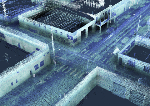
Allvision Parkview Uses Kaarta Platform with Velodyne Lidar to Inventory Roads, Curbs, and Sidewalks
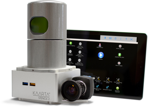
“The addition of Stencil 2-32 to Kaarta’s product line further extends the range of mapping applications for mobile lidar scanning,” said Kevin Dowling, Ph.D., CEO, Kaarta. “The low noise, long range, and field of view of Velodyne’s compact lidar sensors allow us to create systems with immense versatility, accuracy, and speed - from capture to answer.”
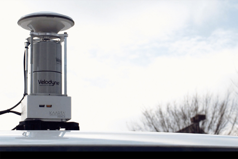
Stencil integrates 3D mapping and real-time position estimation to create capabilities not possible with fixed-base scanning systems. Stencil 2-32 incorporates the Velodyne HDL-32E lidar sensor, which provides a range of 100 meters and a data rate of 720,000 points per second. Kaarta leverages advanced robotics technology that combines input from multiple sensors - lidar, visual odometry, and inertial measurement unit (IMU) - and processes that data in real time. For some applications, the data can be enhanced with Global Navigation Satellite System (GNSS) positioning and wheel odometry sensors.
“Velodyne lidar and Kaarta’s advanced 3D mapping and localization algorithms are a phenomenal combination, creating a portable system for fast and easy detailed surface mapping,” said Aaron Morris, Founder and CEO, Allvision. “The ability to rapidly gather accurate and up-to-date geospatial information has countless applications.”
Stencil 2-32 is the newest member of Kaarta’s Stencil product line which also includes Stencil 2-16, a versatile low-cost mobile mapping platform that uses the Velodyne Puck™ sensor. Its ease of use, breadth of applications, and streamlined workflow make the system well-suited for infrastructure inspectors, surveyors, engineers, architects, facilities planners, security personnel, and more.
“Kaarta and Allvision demonstrate how to tap the full potential of Velodyne’s rich computer perception data for an innovative solution to inventory, track, and monitor assets for accurate future planning and management,” said Mike Jellen, President and CCO, Velodyne Lidar.
About Velodyne Lidar
Velodyne provides smart, powerful lidar solutions for autonomy and driver assistance. Founded in 1983 and headquartered in San Jose, Calif., Velodyne is known worldwide for its portfolio of breakthrough lidar sensor technologies. In 2005, Velodyne’s Founder and CEO, David Hall, invented real-time surround view lidar systems, revolutionizing perception and autonomy for automotive, new mobility, mapping, robotics, and security. Velodyne’s high-performance product line includes a broad range of sensing solutions, including the cost-effective Puck™, the versatile Ultra Puck™, the autonomy-advancing Alpha Puck™, the ADAS-optimized Velarray™, and the groundbreaking software for driver assistance, Vella™.
About Kaarta
Kaarta is the innovator of real-time mobile 3D reality capture, mapping complex environments with unprecedented speed, fidelity and ease. Kaarta works without external signal infrastructure such as GPS or Wi-Fi. Kaarta’s patent-pending technology, rooted in advanced robotics, accurately transforms the real world into 3D digital twins, streamlining workflow, reducing time, lowering cost, and providing a new level of understanding of spaces for humans and autonomous machines alike. Now the spectrum of stakeholders across architecture, engineering, construction, and property owner/operators, facilities planners and managers, and mobile robotics developers can work from the same truth. Additional information is available at www.kaarta.com.
View source version on businesswire.com: https://www.businesswire.com/news/home/20190716005210/en/
Website: http://www.velodynelidar.com
Contact
Landis Communications Inc. for Velodyne Lidar, Inc.
Sean Dowdall
+1 (415) 286-7121
velodyne@landispr.com
Kaarta
Kathy Pattison
+1 (617) 515-6946
media@kaarta.com
기자 검색부터 배포·모니터링까지 한 곳에서 끝내세요
-
2022년 12월 2일 13:30
